Tag Archives: household archaeology

Stone Foundations and Tent Platforms in NW Coast Archaeology

Tlingit house with stone wall foundation near Juneau, Alaska.  Source: SHI Archives, Richard Wood collection. http://goo.gl/hH9Pfl

Tlingit house with stone wall foundation. “Photograph of a Taku village homes, photo likely by Partridge, circa 1887. Village site was located on the mainland across from Douglas Island, south of present-day Juneau”: SHI Archives, Richard Wood collection. http://goo.gl/hH9Pfl

We’re a little obsessed with wooden architecture in the NW Coast archaeology world – with good reason, I guess, since monumental wooden houses are such a prominent feature of the recent past. I suppose we sometimes stereotype these houses a little – a point some commenters made in the Houses on Stilts post here a while back – we think: “large rectangular house squatting in midden supported by giant house posts.” Not always the case, certainly not through time.

In general, we may underestimate large scale constructions in stone.  Burial cairns and mounds (one of Darcy’s consists of 18 dump-trucks worth of soil), rock wall defensive sites, trench embankments, canoe runs, fish traps, and of course, clam gardens, all involved massive deployments of stone, with associated labour investments and creation of a durable built environment. Anyway, we’ve recently been running into enigmatic rock structures on the central coast and Quadra Island, and in particular, the possibility of dwelling structures partially based on stone walls.  So it’s quite cool to run across the picture above from the SHI photo collections, showing a Taku Tlingit house from the historic period, sitting on a platform which has a stone wall as a foundation.

Continue reading

Interior of a Coast Salish Longhouse, 1864

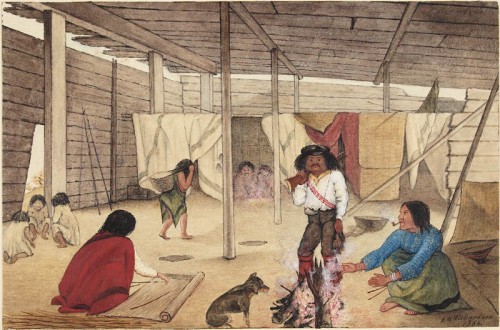
Interior of a Salish Longhouse, 1864. Watercolour by Edward Mallott Richardson.  Locale uknown. Source: Canadian Archives.  Click to enlarge.

Interior of a Salish Longhouse, 1864. Watercolour by Edward Mallott Richardson. Locale uknown. Source: Canadian Archives. Click to enlarge.

Following on from the post about the Salish mausoleum, here is a companion painting by Edward Mallott Richardson from the same year, depicting the interior of a house.  It’s a curious painting, seemingly devoid of close detail.  Where are all the drying fish?!  But at the same time it shows some features of interest which may be worth discussing.  Note the fellow with the gun has a powderhorn, for example, and the basket behind him looks like one of those rectangular coiled ones, only with a tumpline, as shown by the woman entering on the left.  On the far right is a semi-conical object that might be a hat, sitting on a platform within a small compartment.

Continue reading

Victoria ASBC Public Talk, Tuesday May 17: Locarno Houses?!

UVIC students visiting "Aquattro Site" near Esquimalt Lagoon, 2008.

The next scheduled public talk of the Archaeological Society of BC, Victoria Chapter, will be held next Tuesday evening at 7.30 at the Pacific Forestry Centre, 506 West Burnside Road (map).  The talk is free and open to any member of the public.

The talk is entitled Preliminary Investigation Results from DcRu-1151: A Locarno-Age Living and Processing Site at Esquimalt Lagoon, and will be given by local archaeologists Kristi Bowie and Kira Kristensen.

I had the pleasure of visiting this site while it was being excavated a few years ago.  All signs were that the site included the remains of a house dating to between 2500 and 3500 years ago, the “Locarno Beach” period, though at that time the feature was not directly dated.  Very little is known of domestic structures from this time and so the finds could be quite exciting. I’m looking forward to hearing more about this site, though it is doubtful I will be able to attend this talk due to the ongoing circumstances which also keep this blog running slowly.  I am pasting in the abstract and speaker biographies below, or else click here for the PDF.

Continue reading

Bridge River Housepit Geophysics

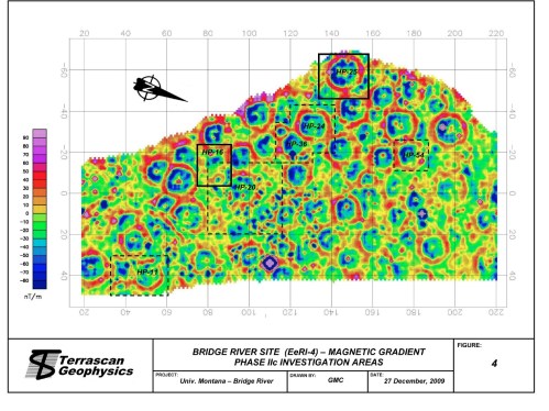
Magnetometry map of the Bridge River Site housepits. Source: Prentiss et al. 2009

Wouldn’t it be nice to be able to see what was underground without having to go through the time-consuming, expensive and destructive process of digging it up?  There are some nice geophysics techniques in archaeology for doing just that, though none are yet a substitute for excavation.  I noticed the other day (and you were quizzed on it) that there is a very comprehensive recent report online (45 meg PDF) by Anna Marie Prentiss and colleagues, on work at the middle Fraser pithouse village of Bridge River (EeRl-4).  This village lies in the territory of Bridge River Band (Xwisten) and the St’át’imc Nation.  While there is a huge amount of archaeological interest across the 350 page report as a whole, it was the use of geophysics on an interior pithouse village which got my attention.

Continue reading

Houses on Stilts

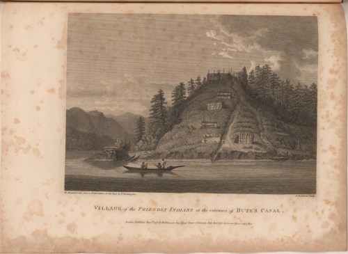
"Village of the Friendly Indians at the Entrance of Bute's Canal", 1792. Click for zoomable version.

The above image shows a seemingly improbable Kwiakah Kwakwaka’wakw Village (EDIT: probably Homathko Coast Salish Village) at the entrance to Bute Inlet, as drawn in 1792 by a member of Captain Vancouver’s expedition.  With the houses scattered up a steep hillside, the top one apparently partially cantilevered out, it does not fit the average archaeologist’s mental model of a typical Northwest Coast village.  The setting would undoubtedly have some defensive advantages, at least for those at the top.  I know of another image of a steeply-tiered village site which is apparently not strictly a defensive site.  Hard to live on the side of such a steep hill, you might think.  Wouldn’t it be nice to have photographs of such a village?  Aha.

Continue reading

Salish Villages of Puget Sound

Overview map of Coast Salish Villages of Puget Sound. Click to go to the page of interactive maps at coastsalishmap.org

Tom Dailey has put together a large and very interesting site which documents the Coast Salish villages of Puget Sound.  The core of the site is a series of clickable maps (see the left hand side black/white map grid), each of which is marked with little village icons.  Clicking on these icons takes you to a master document with a synopsis of the settlement name and, usually, a couple of sentences about the village.  These are referenced to scholarly literature and other sources.  It is striking to see all these villages on one map, and notable how many are shown on rivers and lakes.

Continue reading

Webber’s Village in Nootka Sound: Original Watercolour

Painting of a village in Nootka Sound, 1778, by John Webber. Source: State Library of New South Wales. Click for larger original.

Yesterday I linked to the original watercolour of a 1778 Nootka Sound house interior by John Webber, which is the basis for the widely reproduced engraving.  Today we can take a look at Webber’s original painting of a Nootka Sound village, presumably Yuquot but not so labelled, as found at the State Library of New South Wales (though yesterday’s post brought forth questions as to whether these are watercolours or coloured engravings – see the comments).  The first and most important point is, see that lumpy, dissected landform in front of the houses?  That, my friends, is what an active shell midden looks like.  No wonder they can be such stratigraphic nightmares.

Continue reading

Webber’s House Interior: Original Watercolour

1778 Watercolour by John Webber of the interior of a house in Nootka Sound. Source: State Library of New South Wales. Click for original.

A few days ago I posted a beautiful watercolour of Nootka Sound by John Webber, artist on Cook’s third voyage.  In the ensuing discussion, it was brought up how nice it would be to see the original watercolours of more of his paintings, which often formed the basis for the  numerous engraved reproductions which are what one normally sees.  The loss of information in moving from the original to the engraving is something of an unknown quantity, and I for one had never seen the watercolours.  Until yesterday!

Continue reading

Speaking of Ozette: dSpace resources.

The "White Series" Ozette reports are freely available for download! Image shows house-plank decoration from the Ozette Site, used as cover art for these reports.

This space has recently carried a lot of items about the Ozette water-saturated site on the Olympic Peninsula,  about Makah whaling, and Queets canoes, and other wet sites in Washington State.  All archaeologists and many of the public in the Northwest are familiar with the Ozette site which, with its fabulous preservation has stimulated a lot of work on the archaeology of the big houses which so characterise the culture area from the Columbia to the Gulf of Alaska. A principal way most archaeologists are familiar with Ozette is through the three large  site reports published by Washington State University, bound as large white paperbacks, and found on the bookshelf of archaeologists across the region.

So, imagine how happy I was to find that all three volumes are available as free PDF downloads from Washington State University.  The PDFs are very large, perhaps un-necessarily so, but who can complain about over a thousand pages of detailed archaeological information on one of the most significant archaeological sites in North America, or even the world?  The three volumes are:

  • Samuels et al.  Ozette archaeological project research reports Volume I House structure and floor midden. 1991.  Link to download page.  (193 megs)
  • Samuels et al. Ozette archaeological project research reports volume II Fauna. 1994.  Link to download page(154 megs)
  • Whelchel et al.  Ozette archaeological project research reports volume III ethnobotany and wood technology.  2004.  Link to download page.  (288 megs).
  • While you’re at it, pick up Dale Croes’ pioneering 1974 computer applications in archaeology paper: The use of computer graphics in archaeology : a case study from the Ozette site, WashingtonLink to download page.  (149 megs).

UPDATE March 3/2010:  the handle.net URLs have been broken for a couple of days.  Try this link to get straight to WSU dSpace for Ozette. If that breaks ( a lot of places prevent stable URLs from search results because obviously people never want to share things) then go here and enter “ozette” in the search box.

(Note: all the above documents may download as files named “ARI” with no file extension.  You will need to add the extension .PDF to the file before you open it.)

These PDFs are fully searchable which makes finding things within the copious material of the Ozette site much easier.  The huge number of artifacts, features and fauna from Ozette have been a blessing and a curse, as interpretation struggles under the dead weight of data.  I would therefore be remiss if I didn’t bring to your attention the excellent M.A. thesis on Northwest Coast household archaeology by UVIC’s own Brendan Gray, who uses Ozette as a test-bed to investigate how we might be able to dig less but dig smarter and therefore learn more from Northwest houses.  Every NW Coast archaeologist should read this thesis.

  • Gray, Brendan 2009.  Sampling methods in Northwest Coast household archaeology: a simulation approach using faunal data from the Ozette siteLink (a bargain at 4.8 megs)

Anyway, I know many readers might find this to be too much inf.ormation, but I don’t believe it is common knowledge that these full text Ozette reports are freely available:  the WASU servers are fast, hard drives are cheap, and the reports are first class.  Enjoy.

Simulated and actual sampling designs projected onto Ozette house floors. From Brendan Gray M.A. thesis.

Memories of Ozette

Makah whaler Wilson Parker posing as a MAKAH WHALER for Edward Curtis, ca.1915

The magazine of Washington State University has a nice article on the archaeological project at Ozette, the UNESCO World Heritage Site on the west side of the Olympic Peninsula.  This Makah village site was covered by a landslide about three hundred years ago (animation), which created preservation conditions highly favourable to preservation of wooden artifacts.  The story begins

THERE’S A WELL-KNOWN PHOTOGRAPH taken by Native American chronicler Edward Curtis in 1915 of a Makah whaler. Dressed in an animal skin, the man is longhaired and wild. He had indeed been a whaler, as had generations of his people. But still, the photograph is a memory of a time already past. Curtis provided Wilson Parker with a hide and a wig to replace the European clothes the Makahs had adopted long before. In spite of Curtis’s fiction, however, there is much to be learned from Wilson Parker, the man in the photograph. As is always the case with a good myth, there is a deeper truth that lies beneath the surface story.

Parker is Sharon Kanichy’s great-great-grandfather, she tells me as we talk in the Makah cultural center in Neah Bay. Kanichy ’01 was born in February 1970. That same month, a powerful storm blew in off the Pacific, eroding the bank above the beach at Cape Alava, on the Olympic Coast, revealing something remarkable.

“All we knew was there was a burial site,” says Ed Claplanhoo of the buried longhouses revealed by that February storm. Claplanhoo ’56 was Makah tribal chairman in 1970, so it was he who got a phone call the first Saturday in February, from a hippie schoolteacher, as Claplanhoo describes him. A dubious character, says Claplanhoo, which is why he didn’t take the fellow seriously when he tried to warn Claplanhoo that “people” were getting in the “house” and taking “artifacts.” Claplanhoo knew everyone in Neah Bay and knew everyone who owned artifacts. He’d heard of no problems.

But the fellow persisted. The next Sunday, the same phone call. “Mr. Claplanhoo, they’re still taking artifacts out of the house.”

“So I said okay,” says Claplanhoo, “I’ll tell you what, you come to my house at seven o’clock tonight and we’ll talk about it.”

From there, the article recounts the story of the Ozette excavations from the point of view of both Makah and the archaeologist Richard Daugherty, who led the decade long excavation of “North America’s Pompeii.”  It nicely captures the importance of the site as well as the nature of the dig and the social relations formed which endure to this day.

Don’t miss the slideshow from the excavations — it’s an awkward interface but some very atmospheric pictures of life on a remote archaeological dig in the 1960s – as well as a few shots of the US Marines who helped airlift supplies in and treasures out.

Digging at the Ozette Site - the hoses were used to gently free the wooden artifacts, such as the house planks shown, from the mudflow which buried them. Source: WASU Magazine.