Tag Archives: Washington State

These Outer Shores: A special edition of BC Studies

Screen Shot 2015-11-08 at 7.47.48 PMThe regional journal BC Studies has a new special issue out focused on local archaeology. Entitled These Outer Shores, the edition is available for a reasonable price (20$) and two of the articles plus the forward are already open access, with the rest to follow in a couple of years.  The publisher’s blurb gives a good sense of the edition:

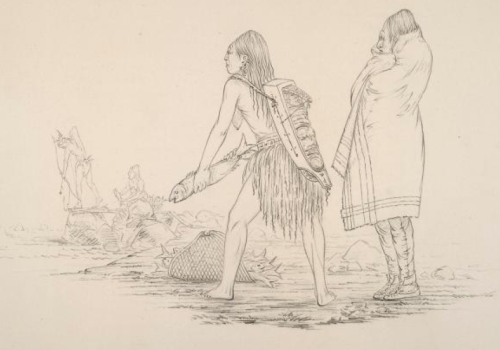
Guest Edited by Alan D. McMillan and Iain McKechnie, These Outer Shores presents recent archaeological research along the outer coast, from southeast Alaska to the entrance to Juan de Fuca Strait. The authors challenge the long-held perception of the western edge of British Columbia as “peripheral” or “remote,” removed from major cultural developments emanating from more interior locations. Instead, recent fieldwork and analyses document a lengthy and persistent occupation of the outer shores over the past 13,000 years. Using a variety of modern approaches and techniques, the authors examine such topics as changing sea levels, human settlement history, fish and shellfish harvesting, whaling, and the integration of Indigenous oral history with archaeology.

Continue reading

Harpoon Arrows

Fishing at the Dalles, 1850, pencil drawing by George Catlin. Source: NYPL.

Fishing at the Dalles, 1850, pencil drawing by George Catlin. Source: NYPL.

I’m probably the last person to get the memo that you can fire a harpoon with a bow and arrow.  In fact,  I only just got my head around firing a harpoon with an atlatl.  Anyway, take a squint at the picture above – the figure in the lower left background is clearly shooting a harpoon-arrow from his bow.  The picture is from about 1850 and is a pencil drawing of a scene at The Dalles, on the Columbia River.  I’ll take a closer look at this picture below. Continue reading

Historic Newspaper Archive on Google

Sooke Freight! Vancouver Daily Post, 1865.

Via the Northwest History blog, I recently found that Google has been quietly archiving a large number of  historical newspapers, including many defunct ones from the west.  Old newspapers are a rich source of social history and can fill in some details of everyday life in the early historical period.  For example, it still costs me about 2 & 1/2 cents per pound to get my sorry self from Victoria to Leech River.  Or, see the table below from 1864 recounting the travel time and cost by stage or foot from New Westminster to the Columbia River. That’s better history than some dumb vote of useless politicians.

As Larry Cebula at Northwest History points out, Google has buried this feature somewhat.  There is a master list of all newspapers here, though, and you can work your way through that.  Many of the newspaper names are cryptic, though, and since I usually do the grunt work for you, here are some of the historic, often defunct, newspapers of particular interest to readers of this blog:

Continue reading

East Wenatchee Clovis Photo Gallery

One of the East Wenatchee Clovis Points. Source: Washington State Historical Society.

A few months ago I posted about the surface finds, or other finds without archaeological context, of the Clovis archaeological culture in Puget Sound, noting that this shouldn’t be all that surprising considering the well-known East Wenatchee (Richey-Roberts) Clovis Cache from just east of the Cascades.  Clovis, as you may know, is an archaeological culture type long associated with the first peopling of the Americas, although a decreasing number of archaeologists think it reflects that series of events.

Anyway, you can review that other post for more details.  What I’ve subsequently found is that the Washington State Historical Society has a colour gallery of all 49 of the artifacts from East Wenatchee.  The pictures are not particularly high resolution but they are well-taken and well-lit and better than most you’ll find on the web.  You can match the projectile points up to this diagram if you are feeling keen, or compare to the pictures at the lithic casting lab, some of which have hands and other useful sizing aids in them.

Even so, since they were scanned from 4 X 5 inch format negatives, it’s disappointing there is no higher resolution downloadable.  For a fringe interest like this, and considering that bandwidth is practically free, let’s make this stuff available.  You can click on the view options to, for example, see both sides of the artifact displayed at once.  It’s also very surprising that there is no photo scale and dimensions are not given.

Continue reading

Seattle waterfront archaeology

"Native American encampment on landfill, circa 1900, south of South Royal Brougham Way and east of First Avenue South." Source: crosscut.com

At the ASBC talk last night it was clear that major industrial development can still leave substantial and highly significant archaeological materials interspersed even within the boundaries of heavy impact – in this case within a few dozen metres of a major hydroelectric dam.  This reminded me of a recent story I read about downtown Seattle archaeology.  Due mainly to concerns about what would happen in even a moderate earthquake comparable to the Nisqually event of 2001, Seattle is planning to replace the Alaska Way viaduct – that multi-level highway which blocks the city from its own waterfront.  You can watch a video of a simulation of the collapse of the viaduct here – I am sure most Seattlers would like to be done with that uncivic monstrosity, but not, perhaps, so suddenly.  Ironically, the ASBC talk on Ruskin Dam was also a seismic upgrade project.

Anyway, the current plan in Seattle is to put a cut-and-cover tunnel in its place – similar to some of the tunnels recently built in Vancouver’s new Canada Line LRT.  Crosscut.com’s Archaeology-savvy reporter “Mossback” (Knute Berger) has two excellent articles on the problems likely to arise when you dig such a large ditch through dense pre-contact and historic archaeology.  The first article ran on May 11th, with the followup article on May 12th.  If you are truly dedicated, there is a 200 page overview (6 meg PDF) of cultural resource management for the project, though it largely focuses on historic buildings and it relatively vague.

Continue reading

Mount St. Helens and experimental archaeology

Paul Kane: Mt. St. Helens erupting by night, 1847. Source: Wikipedia

Today is the 30th anniversary of the cataclysmic eruption of Mount St. Helens, an explosion so large that it could be heard as far north as southern Vancouver Island.  The mountain has erupted many times in the past – one of which was captured by the well known painter Paul Kane (above) – and will continue to erupt indefinitely.  Many of these eruptions and its fickle nature loom large in oral histories.  The ash from prior eruptions forms important geological marker horizons all over the Northwest.  Judging by this map, there are no known obsidian sources directly associated with Mount St Helens.  These are the more obvious kinds of connections to archaeology and they shouldn’t be discounted. Another approach exemplifies a kind of morbidly creative lateral thinking.

Continue reading

Convictions in Yakima Looting Case, with comments on B.C.

Looting at Wakemap Mound, 1957.

A news snippet from Washington State: from the Yakima Herald-Republic, via the excellent Washington Department of Archaeology and Heritage Preservation Blog.

“Yakima, Wash. — Two Goldendale residents found guilty of looting American Indian artifacts from a Yakama Nation cultural site have been sentenced to pay $6,690 in damages and placed on two years probation. The pair have also been sentenced to 150 hours each of community service.Devin Prouty, 27 and Tiffany E. Larson, 24, both pleaded guilty in U.S. District Court to unlawfully removing artifacts, including rocks, rock flakes made by indigenous people and arrowheads from Spearfish Park near the Columbia River in Klickitat County…”

Looting is a serious problem in Washington and Oregon States but is it one in British Columbia as well?

Continue reading

Waatch River: a raised beach site on the Olympic Peninsula

View from West up Waatch River Valley to Neah Bay; Vancouver Island in the distance. Source: Panoramio user Sam Beebe.

The Waatch River flows in a low valley that connects Neah Bay across the Olympic Peninsula to Makah Bay.  When sea levels were higher, it would flood with sea water and turn Cape Flattery into an island.  Interesting, then, to see that an old raised beach site has been found on the Waatch River at an elevation of about 13 metres above, and 2 km away from, the modern shoreline.

Continue reading

Bears, Humans and Deer: disambiguation at last.

Human and Bear cuboid bones compared. Source: Smart 2009.

Some graduate theses are clearly meant to be both a research excercise and produce a demonstrably useful document.  I’m not saying these are any better than any other kind of thesis, but they do have an aura of public service and virtue about them.  The best example of these which I have seen recently is Tamela Smart’s 2009  Carpals and tarsals of mule deer, black bear and human: an osteology guide for the archaeologist.  If you click here it will start an automatic download of the 3.7 meg PDF from Western Washington University (unfortunately, no way to link to a download page).  (edit: try this link instead)

The premise of this research is that despite obvious differences on the outside, there are surprising similarities between the hand/wrist and ankle/foot bones (carpals and tarsals) of bears, deer, and humans.

Continue reading

Mammoth Wenas

Mammoth Wenas. Source: CWU.edu; painting by Bronwyn Mayo.

For the past few years, students and faculty from Central Washington University have been excavating terminal Pleistocene fauna, including a partial mammoth skeleton, from the Wenas Creek area just north of Yakima (map), and they have a nice website documenting their work.  Radiocarbon dates on the mammoth came back at 13,400 and 14,000  radiocarbon years ago, or about 16,000 calendar years ago.  Too old for archaeological interest!  Right?

Continue reading